April 2019 Forecasts and Discussions

Weather reports, analysis etc. pertaining to Southern BC.
Post Reply
User avatar
Canada Goose
Weather Enthusiast
Weather Enthusiast
Posts: 2208
Joined: Mon Feb 18, 2019 12:41 pm
Location: Port Coquitlam (Downtown) - Banana Belt
Elevation: 11 m
Has thanked: 741 times
Been thanked: 4548 times

Re: April 2019 Forecasts and Discussions

Post by Canada Goose »

Typeing3 wrote: Sun Apr 28, 2019 11:22 am Looks like we will end April with nearly 200mm of rain at the North Coquitlam station. Hope to see a nice dry stretch with several 20C+ days soon.
Yep!

192.5mm there and 183mm here.
User avatar
Monty
Weather Enthusiast
Weather Enthusiast
Posts: 4459
Joined: Sun Feb 17, 2019 2:56 pm
Has thanked: 930 times
Been thanked: 9187 times

Re: April 2019 Forecasts and Discussions

Post by Monty »

Snowed_in wrote: Sun Apr 28, 2019 10:41 am Anyone see the snowstorm in Calgary :lol: no wonder the flames got doused so easily.
There was a blizzard warning around Lethbridge. Moderate snow and winds gusting to 90kmh early this morning
North end of Shawnigan Lake. Southern Vancouver island. 500ft
User avatar
AbbyJr
Storm Chaser
Storm Chaser
Posts: 5299
Joined: Sun Feb 17, 2019 2:14 pm
Location: Abbotsford
Elevation: 50m(164ft)
Has thanked: 9559 times
Been thanked: 9244 times

Re: April 2019 Forecasts and Discussions

Post by AbbyJr »

Monty wrote: Sun Apr 28, 2019 12:06 pm There was a blizzard warning around Lethbridge. Moderate snow and winds gusting to 90kmh early this morning
Weather summary
for Alberta
issued by Environment Canada
at 4:13 p.m. MDT Sunday 28 April 2019.

Discussion.

A strong low pressure system brought heavy snow and strong winds to
much of central and southern Alberta Saturday into Sunday morning.
Snowfall, winter storm, and blizzard warnings were issued in advance
of the early spring Alberta low. This vigorous system also produced
a few short lived severe thunderstorms in the southeast corner of
Alberta Saturday afternoon, before blizzard conditions descended on
the area Saturday evening and overnight.

Reduced visibilities and strong winds combined to produce poor
driving conditions on highways in the southeast corner of the
province overnight Saturday into Sunday morning. Sections of Highway
1 east of Calgary were closed, as well as others.

The following is a summary of weather event information received by
Environment and Climate Change Canada as of 16:00 MST Sunday, April
28:

1. Summary of snowfall in centimetres:

Cochrane: 32
Carrot Creek: 30
Rimbey: 30
Sylvan Lake: 30
Bragg Creek: 30
Winfield: 25
Crossfield: 23
Sundre: 23
Edson area: 20-30
Airdrie: 13-20
Calgary: 10-20
Kananaskis Village: 20
Nordegg: 18
Olds: 18
Red Deer: 17
Bergen: 15
Edmonton: 5-14
Innisfail: 13
Rocky Mountain House area: 13
Brooks: 12
Whitecourt: 12

2. Summary of peak winds in kilometres per hour:

Reports from observing sites:
Brocket: 107
Travers: 106
Iron Springs: 102
Barons: 98
Fort Macleod: 98
Bull Springs: 96
Champion: 96
Grassy Lakes: 96
Hussar: 96
Milk River: 96
Ralston: 96
Sheerness: 96
Stavely: 96
Bassano: 94
Enchant: 94
Social Plains: 93
Wrentham: 93
Pakowki Lake: 91
Ardenville: 89
Carway: 89
Mossleigh: 89
Onefour: 89
Pinhorn: 89
Lethbridge: 87
Calgary International Airport: 82
Medicine Hat Airport: 82

Reports from highway sites:
Highway 3 east of Range Road 272 near Fort Macleod: 103
Highway 3 west of Barnwell: 102
Highway 2 south of Jct. 519 near Granum: 102
Highway 22 south of Twp Road 91A north of Lundbreck: 100
Highway 1 west of Alderson Gas Plant Road near Suffield: 91

Please note that this summary may contain preliminary or unofficial
information and does not constitute a complete or final report.

End/PASPC
:lol: :lol: :clap: :clap:
Central Abbotsford
50m (164ft)

2022/23 season snowfall: 76.8cm

:team: :snowwindow: :snowman:
User avatar
Typeing3
Weather Psycho
Weather Psycho
Posts: 12105
Joined: Sun Feb 17, 2019 3:02 pm
Location: Coquitlam
Elevation: 25M./80Ft.
Has thanked: 20180 times
Been thanked: 22629 times

Re: April 2019 Forecasts and Discussions

Post by Typeing3 »

AbbyJr wrote: Sun Apr 28, 2019 6:27 pm :lol: :lol: :clap: :clap:
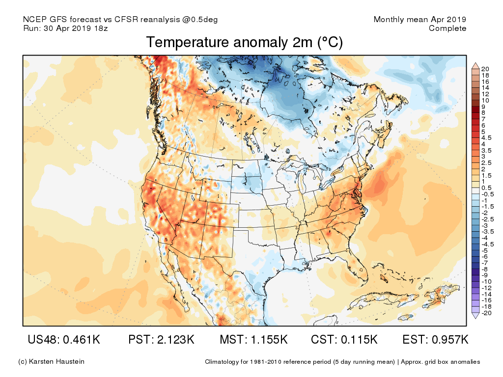
Crazy. Though this is nothing new for Alberta; that September snowstorm Calgary had a few years ago is still fresh in my mind.
:typing: :type3:
East Coquitlam
Elevation 25M (80Ft)
#MrJanuary :geek: 8-)
User avatar
Roberts Creeker
Donator
Donator
Posts: 3776
Joined: Sun Feb 17, 2019 2:17 pm
Location: Upper Roberts Creek
Elevation: 162 M./532 ft.
Has thanked: 21396 times
Been thanked: 6962 times

Re: April 2019 Forecasts and Discussions

Post by Roberts Creeker »

Had ice on a shallow bucket and frost at 9am this morning! :shock: A few of my potato tops are looking unhappy. :( Unusual for the end of April, isn't it?
User avatar
Roberts Creeker
Donator
Donator
Posts: 3776
Joined: Sun Feb 17, 2019 2:17 pm
Location: Upper Roberts Creek
Elevation: 162 M./532 ft.
Has thanked: 21396 times
Been thanked: 6962 times

Re: April 2019 Forecasts and Discussions

Post by Roberts Creeker »

Monty wrote: Sun Apr 28, 2019 12:06 pm There was a blizzard warning around Lethbridge. Moderate snow and winds gusting to 90kmh early this morning
Funny how snow bring the board alive...even if it's not local. :clap: :clap:
User avatar
tyweather
Model Rider
Model Rider
Posts: 1530
Joined: Sun Feb 17, 2019 2:39 pm
Location: Newton, Surrey, EL. 70m
Has thanked: 68 times
Been thanked: 3395 times

Re: April 2019 Forecasts and Discussions

Post by tyweather »

My brother inlaw was camping at Cultus Lake on Saturday. They had a tarp collapse due to snow accumulation of 3 cm. The scouts were not prepared for that.
Why not try cycling to work, grocery store, anywhere!
User avatar
stuffradio
Site Admin
Site Admin
Posts: 2151
Joined: Sun Feb 17, 2019 2:07 pm
Location: Maple Ridge
Has thanked: 3072 times
Been thanked: 5032 times
Contact:

Re: April 2019 Forecasts and Discussions

Post by stuffradio »

12Z GFS appears to have quite the dry stretch between now and the middle of May.
User avatar
PortKells
Storm Chaser
Storm Chaser
Posts: 6391
Joined: Sun Feb 17, 2019 4:08 pm
Location: Port Kells
Elevation: 78m
Has thanked: 554 times
Been thanked: 11026 times

Re: April 2019 Forecasts and Discussions

Post by PortKells »

stuffradio wrote: Mon Apr 29, 2019 11:27 am 12Z GFS appears to have quite the dry stretch between now and the middle of May.
You knew that was coming. Currently it seems were getting stuck in wer/dry patterns for 2 to 3 weeks. Hopefully that's not the end of significant rainfall before the summer.
User avatar
SouthSardiswx
Donator
Donator
Posts: 18681
Joined: Sun Feb 17, 2019 2:37 pm
Location: Chilliwack (South Sardis)
Has thanked: 50898 times
Been thanked: 15619 times

Re: April 2019 Forecasts and Discussions

Post by SouthSardiswx »

Roberts Creeker wrote: Sun Apr 28, 2019 9:43 pm Had ice on a shallow bucket and frost at 9am this morning! :shock: A few of my potato tops are looking unhappy. :( Unusual for the end of April, isn't it?
I was mentioning just last week about frost this late I guess I got my answer my low this morning was 2c just late last week I got down to 2c also with frost on some roof tops.
The 6th annual alzheimer's snowfall contest
:team: Canoodles record: 44-18-8
:gramps: Wrinkle Rockers: 43cm :wtf:
:hockey: South Sardines: 57cm
CYCW station
https://cycw.awos.live/local-weather
User avatar
SouthSardiswx
Donator
Donator
Posts: 18681
Joined: Sun Feb 17, 2019 2:37 pm
Location: Chilliwack (South Sardis)
Has thanked: 50898 times
Been thanked: 15619 times

Re: April 2019 Forecasts and Discussions

Post by SouthSardiswx »

Roberts Creeker wrote: Sun Apr 28, 2019 9:43 pm Funny how snow bring the board alive...even if it's not local. :clap: :clap:
Have you looked at the Calgary forecast for this week it's very winter like all week, not much warm up with more snow chances.
The 6th annual alzheimer's snowfall contest
:team: Canoodles record: 44-18-8
:gramps: Wrinkle Rockers: 43cm :wtf:
:hockey: South Sardines: 57cm
CYCW station
https://cycw.awos.live/local-weather
User avatar
Hawk
Storm Chaser
Storm Chaser
Posts: 6626
Joined: Mon Feb 18, 2019 6:45 pm
Location: Langley/The Similkameeeens
Elevation: 320/3024
Has thanked: 11444 times
Been thanked: 5845 times

Re: April 2019 Forecasts and Discussions

Post by Hawk »

Hey buttees wow what a weekend at the cabin. Snow STARTED Sat morning around 6 am to 830. Temps dropped to -1c by 8:30am. Got about 4 to 5 cm of snow. It then continued on as convective flurries on Saturday high around 6c..then again on Sunday..and surprisingly again today. Sunday and today it was snowing out when temps were reading between 8 and 10c :shock: :shock: during mid day. Today was snow all the way to Cedar #2 Creek on the Hope Princeton and still very wet flakes at Hope Slide at 8c around 4pm. Talk about a troff..dammmm and super low DPs. Geezus. This troff was super impressive. Troffs are my fave
Let's hope this April brings some ~24c sunny days. Yesssss :hearteyes: :hearteyes:
Willoughby Langley at ~320ft / Similkameeeens ~3400ft
User avatar
Mattman
Weather Tracker
Weather Tracker
Posts: 229
Joined: Mon Feb 18, 2019 6:13 am
Elevation: 65 M.
Has thanked: 298 times
Been thanked: 754 times

Re: April 2019 Forecasts and Discussions

Post by Mattman »

We're back to our March '19 pattern: mild, dry & benign. Such a pattern produces the sound of crickets on the weather forum.
User avatar
Monty
Weather Enthusiast
Weather Enthusiast
Posts: 4459
Joined: Sun Feb 17, 2019 2:56 pm
Has thanked: 930 times
Been thanked: 9187 times

Re: April 2019 Forecasts and Discussions

Post by Monty »

April ended up warmer and drier than average at Shawnigan Lake. Temps were close to 1C above normal and precip was 11mm below average
North end of Shawnigan Lake. Southern Vancouver island. 500ft
User avatar
Canada Goose
Weather Enthusiast
Weather Enthusiast
Posts: 2208
Joined: Mon Feb 18, 2019 12:41 pm
Location: Port Coquitlam (Downtown) - Banana Belt
Elevation: 11 m
Has thanked: 741 times
Been thanked: 4548 times

Re: April 2019 Forecasts and Discussions

Post by Canada Goose »

Image

By the way, April 2019 was the 17th rainiest since 1937 in YVR.
Post Reply