February 2025 Forecasts And Discussions
-
AbbyJr

- Storm Chaser

- Posts: 6605
- Joined: Sun Feb 17, 2019 2:14 pm
- Location: Abbotsford
- Elevation: 50m(164ft)
- Has thanked: 12857 times
- Been thanked: 12304 times
Re: February 2025 Forecasts And Discussions
Snowing here and starting to stick. Temperature down to 0.6C with a dew point of -1C. 

Central Abbotsford
50m (164ft)
2022/23 season snowfall: 76.8cm


50m (164ft)
2022/23 season snowfall: 76.8cm
-
AbbyJr
- Storm Chaser
- Posts: 6605
- Joined: Sun Feb 17, 2019 2:14 pm
- Location: Abbotsford
- Elevation: 50m(164ft)
- Has thanked: 12857 times
- Been thanked: 12304 times
Re: February 2025 Forecasts And Discussions
Should be one in my opinion. Looks like they are relying on the GEM and RGEM. Personally, I wouldn't discount the Euro solutions entirely.
Central Abbotsford
50m (164ft)
2022/23 season snowfall: 76.8cm
50m (164ft)
2022/23 season snowfall: 76.8cm
-
wetcoast91

- Storm Chaser
- Posts: 7098
- Joined: Sun Feb 17, 2019 3:12 pm
- Location: New Westminster
- Elevation: 106m
- Has thanked: 6962 times
- Been thanked: 16338 times
-
Rubus_Leucodermis

- Storm Chaser
- Posts: 6342
- Joined: Thu Nov 21, 2019 5:48 pm
- Location: Vancouver
- Elevation: 70 m / 230 ft
- Has thanked: 4874 times
- Been thanked: 12957 times
Re: February 2025 Forecasts And Discussions
Flurries in East Van.
It's called clown range for a reason.
-
Typeing3

- Weather Psycho

- Posts: 14197
- Joined: Sun Feb 17, 2019 3:02 pm
- Location: Coquitlam
- Elevation: 25M./80Ft.
- Has thanked: 26794 times
- Been thanked: 28394 times
Re: February 2025 Forecasts And Discussions
Very light dusting of snow in east Coquitlam. Nice to see a few flakes at least.
East Coquitlam
Elevation 25M (80Ft)
#MrJanuary
-
Rubus_Leucodermis
- Storm Chaser
- Posts: 6342
- Joined: Thu Nov 21, 2019 5:48 pm
- Location: Vancouver
- Elevation: 70 m / 230 ft
- Has thanked: 4874 times
- Been thanked: 12957 times
Re: February 2025 Forecasts And Discussions
Started as drizzle here, now flurries.
It's called clown range for a reason.
-
VanCitySouth

- Weather Enthusiast

- Posts: 3922
- Joined: Sun Feb 17, 2019 2:21 pm
- Location: Vancouver (Langara)
- Elevation: 72 m/236 ft
- Has thanked: 4164 times
- Been thanked: 8316 times
Re: February 2025 Forecasts And Discussions
Please send to me too
2025-26 season stats:
Climo ∞ to 0.5
  GFS
GFS
Season total: 0.5 cm and TWO traces!
Peak depth: 0.5 cm (01/07/2026)
Climo
Season total: 0.5 cm and TWO traces!
Peak depth: 0.5 cm (01/07/2026)
-
wetcoast91
- Storm Chaser
- Posts: 7098
- Joined: Sun Feb 17, 2019 3:12 pm
- Location: New Westminster
- Elevation: 106m
- Has thanked: 6962 times
- Been thanked: 16338 times
Re: February 2025 Forecasts And Discussions
10 to 20cm seems like a major stretch.Cloverdale wrote: ↑Sat Feb 01, 2025 8:58 am It also includes Surrey and Langley
8:45 AM PST Saturday 1 February 2025
Snowfall Warning in effect for:
Metro Vancouver - southeast including Surrey and Langley
Snowfall with total amounts of 10 to 20 cm is expected.
Where: Metro Vancouver.
When: Tonight through Monday morning.
Remarks: A wintry mix of weather conditions is expected to impact the South Coast of B.C. through Monday morning. A period of heavy snowfall is expected tonight and Sunday morning. Accumulations will vary widely across the region, ranging from 10 to 20 cm. The highest amounts will likely occur over higher terrain, but other areas may see locally intense flurries giving reduced visibility and heavy snow accumulation. Precipitation will taper off to wet flurries or showers Sunday afternoon. Another round of heavy snow may develop Sunday night into Monday morning.
Visibility may be suddenly reduced at times in heavy snow. Surfaces such as highways, roads, walkways and parking lots may become difficult to navigate due to accumulating snow.
Prepare for quickly changing and deteriorating travel conditions.
-
Bc_trucker

- Weather Tracker

- Posts: 231
- Joined: Sun Oct 06, 2019 10:54 pm
- Location: Chilliwack
- Elevation: 15 M.
- Has thanked: 716 times
- Been thanked: 871 times
Re: February 2025 Forecasts And Discussions
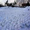
Coming down good here again!
You do not have the required permissions to view the files attached to this post.
East Chilliwack/Rosedale 15m
-
Monty

- Weather Enthusiast
- Posts: 4575
- Joined: Sun Feb 17, 2019 2:56 pm
- Has thanked: 959 times
- Been thanked: 9576 times
Re: February 2025 Forecasts And Discussions
I think I already scored more than the stingy Euro was showing last night. 5.5cm. Maybe the euro is under estimating what’s coming to the lower mainland
North end of Shawnigan Lake. Southern Vancouver island. 500ft
-
VanCitySouth
- Weather Enthusiast
- Posts: 3922
- Joined: Sun Feb 17, 2019 2:21 pm
- Location: Vancouver (Langara)
- Elevation: 72 m/236 ft
- Has thanked: 4164 times
- Been thanked: 8316 times
Re: February 2025 Forecasts And Discussions
Bookmarked
2025-26 season stats:
Climo ∞ to 0.5 GFS
Season total: 0.5 cm and TWO traces!
Peak depth: 0.5 cm (01/07/2026)
Climo
Season total: 0.5 cm and TWO traces!
Peak depth: 0.5 cm (01/07/2026)
-
Radar
- Weather Fanatic

- Posts: 891
- Joined: Sun Feb 17, 2019 7:23 pm
- Location: West Abbotsford
- Elevation: 290ft
- Has thanked: 39 times
- Been thanked: 1667 times
Re: February 2025 Forecasts And Discussions
Bradner Rd conditions at 100m
You do not have the required permissions to view the files attached to this post.
West Abby. Elev. 290ft
PWS: https://www.wunderground.com/dashboard/pws/IABBOT57/
24/25 snow total: 29cm
PWS: https://www.wunderground.com/dashboard/pws/IABBOT57/
24/25 snow total: 29cm
-
Bc_trucker
- Weather Tracker
- Posts: 231
- Joined: Sun Oct 06, 2019 10:54 pm
- Location: Chilliwack
- Elevation: 15 M.
- Has thanked: 716 times
- Been thanked: 871 times
Re: February 2025 Forecasts And Discussions
Does anyone know where the front is currently?
East Chilliwack/Rosedale 15m
-
SnowGeek11
- Cloud Watcher

- Posts: 91
- Joined: Tue Nov 23, 2021 12:42 pm
- Location: West Vancouver
- Elevation: 24 M./79 ft.
- Has thanked: 335 times
- Been thanked: 273 times
-
Michael1
- Weather Nut

- Posts: 798
- Joined: Sun Feb 17, 2019 6:49 pm
- Location: Nanoose
- Elevation: 120 ft.
- Has thanked: 805 times
- Been thanked: 1685 times
Re: February 2025 Forecasts And Discussions
we had a very very scant trace of snow. All gone now, of course. Now we place our hopes in unforeseen circumstances. EC isn't optimistic for us. Our temps dont get that cold and they moderate pretty quickly, throughout the week.
Last edited by Michael1 on Sat Feb 01, 2025 9:22 am, edited 1 time in total.