PortKells wrote: ↑Mon Dec 29, 2025 4:07 pm False. They've been showing Alaskan troughing moving south which is like a unicorn event. Having a retrograding ridge is completely different from what's been shown. Surely you must know that?
You come off like you've been hitting the sauce a little early here bud. Still two days until NYE
December 2025 Forecasts and Discussions
-
HarrisonSasquatchWx

- Donator

- Posts: 22657
- Joined: Sun Feb 17, 2019 2:37 pm
- Location: Harrison Hot Springs B.C.
- Has thanked: 60004 times
- Been thanked: 19783 times
Re: December 2025 Forecasts and Discussions
Current conditions in Harrison Hot Springs:
https://www.wunderground.com/dashboard/ ... wx_pwsdash
https://www.wunderground.com/dashboard/ ... wx_pwsdash
-
walthz

- Weather Tracker

- Posts: 173
- Joined: Tue Nov 30, 2021 6:21 pm
- Location: Squamish downtown
- Elevation: 9M
- Has thanked: 2532 times
- Been thanked: 624 times
Re: December 2025 Forecasts and Discussions
It was only for a few hours, but I was there
-
AbbyJr

- Storm Chaser

- Posts: 6605
- Joined: Sun Feb 17, 2019 2:14 pm
- Location: Abbotsford
- Elevation: 50m(164ft)
- Has thanked: 12858 times
- Been thanked: 12306 times
Re: December 2025 Forecasts and Discussions
I fully agree. I think the Euro is often overhyped. Yes, it’s a very good model and may very well get one of the highest verification scores. But some people talk as if it’s infallible, which is simply not true. I’ve seen its solutions fail to verify on many occasions. In fact, in my opinion, its snowfall maps have been far worse than the GFS this winter. Even last February, it kept outputting ridiculous amounts of snow in the short term that never even came close to verifying. That said, I do trust the Euro more than the GFS, especially when it comes to the short term and medium range. But again, I also think it’s an overrated model.PortKells wrote: ↑Mon Dec 29, 2025 1:15 pm The Euro has been pretty bad this year in my opinion. GFS too obviously. GEM is less talked about but it almost never advertises fake cold blasts and I don't really believe anything until it's on board. Could say the same thing about the AI's, unfortunately.
Central Abbotsford
50m (164ft)
2022/23 season snowfall: 76.8cm


50m (164ft)
2022/23 season snowfall: 76.8cm
-
Catnip

- Moderator

- Posts: 10709
- Joined: Sun Feb 17, 2019 4:01 pm
- Location: Coquitlam (Mundy Park)
- Elevation: 530ft
- Has thanked: 12935 times
- Been thanked: 24059 times
Re: December 2025 Forecasts and Discussions
Guess we need to go with the Euro AI…
Poor GFS…..
Poor GFS…..
You do not have the required permissions to view the files attached to this post.
*Maps are posted for discussion/entertainment purposes only, and not because I necessarily believe them to be true.


#teamsnow #surprises #beginningofFEB #FEB
2025-2026 Snowfall - ZERO.OOcm
Wx Stn: https://tinyurl.com/yxervg27
#teamsnow #surprises #beginningofFEB #FEB
2025-2026 Snowfall - ZERO.OOcm
Wx Stn: https://tinyurl.com/yxervg27
-
Catnip
- Moderator
- Posts: 10709
- Joined: Sun Feb 17, 2019 4:01 pm
- Location: Coquitlam (Mundy Park)
- Elevation: 530ft
- Has thanked: 12935 times
- Been thanked: 24059 times
Re: December 2025 Forecasts and Discussions
You do not have the required permissions to view the files attached to this post.
*Maps are posted for discussion/entertainment purposes only, and not because I necessarily believe them to be true.
#teamsnow #surprises #beginningofFEB #FEB
2025-2026 Snowfall - ZERO.OOcm
Wx Stn: https://tinyurl.com/yxervg27
#teamsnow #surprises #beginningofFEB #FEB
2025-2026 Snowfall - ZERO.OOcm
Wx Stn: https://tinyurl.com/yxervg27
-
snowjoker
- Casual Observer

- Posts: 40
- Joined: Fri Jan 19, 2024 11:35 am
- Location: Richmond
- Elevation: 0 m
- Has thanked: 65 times
- Been thanked: 166 times
Re: December 2025 Forecasts and Discussions
Well it's a fools errand trying to take upper atmosphere 5-day skill scores and apply them to highly variable localized weather patterns, but the GFS is often beaten to the punch by the Euro, GEM, ICON, UKMET and so on... Euro may be overrated but the GooFus is not by any means shining in comparison
Praying for another 1950
-
PortKells

- Storm Chaser
- Posts: 7726
- Joined: Sun Feb 17, 2019 4:08 pm
- Location: Port Kells
- Elevation: 78m
- Has thanked: 589 times
- Been thanked: 13671 times
Re: December 2025 Forecasts and Discussions
If you believe the AI models...This winter is over. They never seem to show anything good coming.
-
wetcoast91

- Storm Chaser
- Posts: 7098
- Joined: Sun Feb 17, 2019 3:12 pm
- Location: New Westminster
- Elevation: 106m
- Has thanked: 6962 times
- Been thanked: 16338 times
Re: December 2025 Forecasts and Discussions
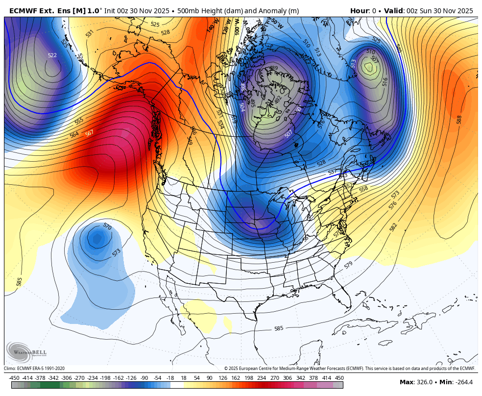
Progression this season. Retrogression in 2024-25. The end result has been a semi-permanent Hudson vortex. Euro LR forecasts may be showing a textbook -ENSO pattern in that 14+ due to the partial input based off climo.PortKells wrote: ↑Mon Dec 29, 2025 4:07 pm False. They've been showing Alaskan troughing moving south which is like a unicorn event. Having a retrograding ridge is completely different from what's been shown. Surely you must know that?
You come off like you've been hitting the sauce a little early here bud. Still two days until NYE
We'll see...this was.the advertised LR forecast for December into January. Had a similar retrogression signal.
-
PortKells
- Storm Chaser
- Posts: 7726
- Joined: Sun Feb 17, 2019 4:08 pm
- Location: Port Kells
- Elevation: 78m
- Has thanked: 589 times
- Been thanked: 13671 times
Re: December 2025 Forecasts and Discussions
That's a remarkably accurate model run that never really shows the ridge placement in the right spot for us. The retrogression is too far north east. Looks more like an alaskan vortex issue to me. Which is kind of what happened but it's breaking down.wetcoast91 wrote: ↑Mon Dec 29, 2025 9:44 pm Progression this season. Retrogression in 2024-25. The end result has been a semi-permanent Hudson vortex. Euro LR forecasts may be showing a textbook -ENSO pattern in that 14+ due to the partial input based off climo.
We'll see...this was.the advertised LR forecast for December into January. Had a similar retrogression signal.
We will see! Probably just going to be another February to Remembuary.
-
wetcoast91
- Storm Chaser
- Posts: 7098
- Joined: Sun Feb 17, 2019 3:12 pm
- Location: New Westminster
- Elevation: 106m
- Has thanked: 6962 times
- Been thanked: 16338 times
Re: December 2025 Forecasts and Discussions
Yeah. We're still in an -ENSO state and activity in the E tropics should simmer down. Odds are we will see measureable lowland snow in February.PortKells wrote: ↑Mon Dec 29, 2025 9:50 pm That's a remarkably accurate model run that never really shows the ridge placement in the right spot for us. The retrogression is too far north east. Looks more like an alaskan vortex issue to me. Which is kind of what happened but it's breaking down.
We will see! Probably just going to be another February to Remembuary.
-
PortKells
- Storm Chaser
- Posts: 7726
- Joined: Sun Feb 17, 2019 4:08 pm
- Location: Port Kells
- Elevation: 78m
- Has thanked: 589 times
- Been thanked: 13671 times
Re: December 2025 Forecasts and Discussions
Cacti for everyone!
Actually moves towards the GFS which is something:
Actually moves towards the GFS which is something:
You do not have the required permissions to view the files attached to this post.
-
Typeing3

- Weather Psycho

- Posts: 14198
- Joined: Sun Feb 17, 2019 3:02 pm
- Location: Coquitlam
- Elevation: 25M./80Ft.
- Has thanked: 26799 times
- Been thanked: 28394 times
Re: December 2025 Forecasts and Discussions
Freeze tonight? Score!
East Coquitlam
Elevation 25M (80Ft)
#MrJanuary
-
PortKells
- Storm Chaser
- Posts: 7726
- Joined: Sun Feb 17, 2019 4:08 pm
- Location: Port Kells
- Elevation: 78m
- Has thanked: 589 times
- Been thanked: 13671 times
Re: December 2025 Forecasts and Discussions
Then you have the GEPS, which is as I always note, never on board unless something is up. Beautiful ridge building into Alaska:
You do not have the required permissions to view the files attached to this post.
-
PortKells
- Storm Chaser
- Posts: 7726
- Joined: Sun Feb 17, 2019 4:08 pm
- Location: Port Kells
- Elevation: 78m
- Has thanked: 589 times
- Been thanked: 13671 times
Re: December 2025 Forecasts and Discussions
GEFS is a banger! Unfortunately it's the GEFS. But that's a strong signal. And it led the way as the other ensembles moved toward it toight. I'm thinking something is brewing...
You do not have the required permissions to view the files attached to this post.
-
Catnip
- Moderator
- Posts: 10709
- Joined: Sun Feb 17, 2019 4:01 pm
- Location: Coquitlam (Mundy Park)
- Elevation: 530ft
- Has thanked: 12935 times
- Been thanked: 24059 times
Re: December 2025 Forecasts and Discussions
*Maps are posted for discussion/entertainment purposes only, and not because I necessarily believe them to be true.
#teamsnow #surprises #beginningofFEB #FEB
2025-2026 Snowfall - ZERO.OOcm
Wx Stn: https://tinyurl.com/yxervg27
#teamsnow #surprises #beginningofFEB #FEB
2025-2026 Snowfall - ZERO.OOcm
Wx Stn: https://tinyurl.com/yxervg27